Using space technologies to monitor and conserve natural and cultural heritage is an emerging hotspot in interdisciplinary study. In recent years, UNESCO has attached increasing importance to the employment of space technologies for protecting and achieving sustainable utilization of its heritage sites. The 34th session of the World Heritage Committee stated in its decision that it would “examine the feasibility of using remote sensing techniques” to monitor and conserve World Heritage sites. HIST will then provide a global platform for such a new interdisciplinary mission.
1. Years of preparation
In 2001, the “Open Initiative on the Use of Space Technologies to Monitor UNESCO Sites” was launched by the European Space Agency and UNESCO. In the same year, CAS, the Chinese Ministry of Education and the State Administration of Cultural Heritage inaugurated the Joint Laboratory of Remote Sensing for Archaeology and set up 10 workstations across China. In the following years, the International Workshop on Remote Sensing for Archaeology was successfully convened in Beijing (2004), Rome (2006) and New Delhi (2009).
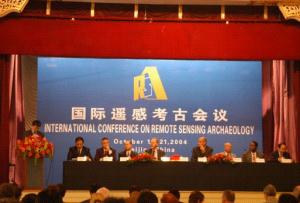
The First International Workshop on Remote Sensing for Archaeology is in session in Beijing, China in October 2004.
Professor GUO Huadong (center), on behalf of the Joint Laboratory of Remote Sensing for Archaeology, signs an agreement to join the “Open Initiative” in Paris in 2005.
In 2006, CAS made an offer to UNESCO to set up a space-technology based center for conserving World Heritage sites. In April 2004, a delegation led by then CAS President LU Yongxiang visited the UNESCO headquarters and met with Marcio Barbosa, then Deputy Director-General of UNESCO, to discuss the issue. In May, LU wrote to then Director-General of UNESCO Koïchiro Matsuura to officially propose the establishment of such a center within the premises of CEODE. Matsuura responded positively to LU’s letter, and instructed relevant departments to undertake a feasibility study on the proposed center and present it to the UNESCO Executive Board.
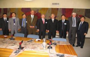
A delegation led by then CAS President LU Yongxiang visits UNESCO headquarters in April 2004.
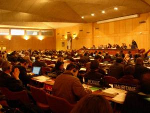
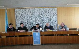
The 35th session of the UNESCO General Conference.

Relevant documents of the 179th Executive Board Meeting and the 35th session of General Conference of UNESCO.
In November 2007, specialists from UNESCO visited CEODE and finished the feasibility report, which passed the examination of the 179th UNESCO Executive Board Meeting and was later approved by the 35th session of the UNESCO General Conference. In April 2011, the Center was ratified by the Chinese State Council with joint efforts from the Ministry of Foreign Affairs, the National Commission of the People's Republic of China for UNESCO, the Ministry of Housing and Rural-Urban Development and the State Administration of Cultural Heritage. In June 2011, on behalf of the Chinese Government, CAS President BAI Chunli signed the agreement with UNESCO Director-General Irina Bokova, marking the legal establishment of HIST.

Irina Bokova (right), Director-General of UNESCO and SHI Shuyun (left), Permanent Delegate of the People's Republic of China to UNESCO.
CAS President BAI Chunli (center) signs the agreement on behalf of the Chinese Government.
2. Experts helps direct HIST’s future development
CEODE has set up the HIST Scientific Committee, comprising some 30 experts and scholars in related scientific fields, to probe into space technologies for World Heritage conservation and to outline the development outlook and deployment of HIST. During the first council meeting of the first session of the Committee convened on June 20, 2011, experts discussed and offered advice to HIST’s strategic planning and research orientation. On July 24, 2011, HIST assembled the first session of its International Governing Board and laid out its strategic goals and research directions.
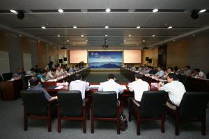
The first council meeting of the first session of the HIST Scientific Committee convened in Beijing in June 2011.
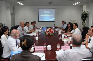
The first session of the HIST International Governing Board takes place in Beijing in July 2011.
3.1 Strategic goals of HIST
Using space technologies, HIST will assist UNESCO and its Member States in their endeavors to monitor and evaluate natural and cultural heritage sites and biosphere reserves and to combat climate change and natural disasters. HIST will build itself into a demonstrative center using space data for World Heritage conservation, provide services including network inquiry, technical information support and personnel training, and make unique contributions to the management and protection of worldwide heritage sites.
3.2 Major research directions
l Establishment of a space-image and environment database for managing heritage sites
By using satellite and airborne remote-sensing data and by combining earth science and environmental science, HIST will set up a network-based database for remote-sensing images and environment information of worldwide World Heritage sites and achieve integrated management of all data.
l Space-based dynamic monitoring of land changes in typical heritage sites
HIST will apply multidimensional and multisource remote-sensing data to monitoring and evaluating typical natural and cultural heritage sites, and provide a scientific basis for the decision-making of local administrators.
l Study on the impacts of global change and natural disasters on heritage sites
HIST is to monitor and evaluate the heritage sites in regions threatened by extreme weather and disasters, and analyze the impacts of climate change and natural disasters on those sites.
l Scenario simulation and reconstruction of large-scale heritage sites
HIST will carry out 3D visualization demos of large-scale World Heritage sites such as the Great Wall, the Grand Canal and the Silk Road.
The International Centre on Space Technologies for Natural and Cultural Heritage (HIST) Officially Opens with Launch Ceremony
Sunday July 24, 2011
BEIJING — The International Centre on Space Technologies for Natural and Cultural Heritage (HIST) was officially inaugurated in a ceremony on July 24th under the auspices of UNESCO and with support from its host, the Center for Earth Observation and Digital Earth (CEODE), Chinese Academy of Sciences (CAS).
HIST is the first centre of its kind to apply space technologies to monitoring and preserving natural and cultural heritage. HIST’s goal is to build the capacity of UNESCO Member States to use space-based Earth observation to monitor, document, model, and present natural and cultural heritage sites of national or international significance.
The ceremony was kicked off with a 3D movie showcasing the applications of space technologies in world heritage preservation, and another demonstrating CEODE’s Digital Earth Science Platform. Guo Huadong, the Director-General of CEODE and Director of HIST, outlined HIST’s objectives and proposed research activities for the coming years, and gave an overview of how HIST will be structured and administered. Mario Hernandez, Senior Programme Specialist at UNESCO, introduced UNESCO's "Open Initiative" involving space agencies exploring the use of space technologies for the monitoring and preservation of heritage. He used examples from around the world to demonstrate how Earth observation can help in this endeavor. There were also key addresses given by Xu Guanhua, CAS Academician and former Minister of the Ministry of Science and Technology, Ding Zhongli, CAS Academician and Vice President of the Chinese Academy of Sciences, and Gretchen Kalonji, Assistant Director-General for Natural Sciences at UNESCO.
The ceremony was preceded by HIST’s first session of the Governing Board. The meeting was mainly intended to establish and approve administrative matters, but the board also explored potential research projects and partnerships. The board is comprised of experts from around the world who specialize in fields related to Earth observation and natural and cultural heritage.
Increasing human and environmental threats to natural and cultural heritage sites led UNESCO and the European Space Agency to establish an “Open Initiative” encouraging all space agencies and related research institutions to use space technologies to support world heritage. The Chinese Academy of Sciences joined the initiative in 2005, and HIST is a product of their continued partnership with UNESCO.
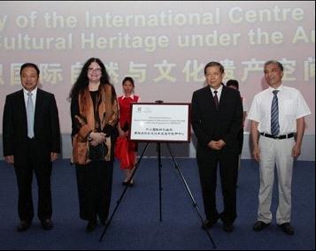
Guo Huadong, Gretchen Kalonji, Xu Guanhua, and Ding Zhongli unveil the HIST nameplate
3. Make contributions by giving play to strengths
In applying for HIST’s establishment, preparation for its construction was made with the support from leaders at different levels.
3.1 Inspection of leaders
Vice-chairman of the Standing Committee of the National People’s Congress and former CAS President LU Yongxiang has paid sustained attention to the proposal and preparation of this center and offered his instructions for its future construction and development. He paid an inspection visit to the center in June, 2011.
Vice-chairman of the Standing Committee of the National People’s Congress LU Yongxiang visiting HIST in June, 2011.
CAS President BAI Chunli, who holds great expectations for the construction and development of the center, created a piece of Chinese calligraphy with the center’s name. Accompanied by the CAS Vice President YIN Hejun, he toured the center in July, 2011.
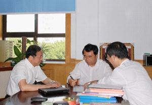
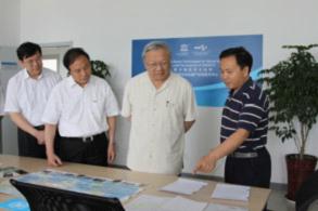
HIST is run by a system of directors with responsibilities under the leadership of an administrative committee. Serving as Director-General of the Administrative Committee, CAS Vice President DING Zhongli has paid much attention to the preparation and construction of the center. He visited HIST and listened to its work report in December, 2010.

CAS Vice President DING Zhongli (center) listening to the work report of the center in December 2010.
3. 2 Atlas of Remote Sensing for World Heritage, China
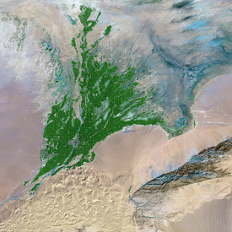
To better promote the role of RS technology in monitoring and protecting World Heritage, HIST has published the Atlas of Remote Sensing for world Heritage, China, which includes a number of satellite and airborne RS images of 40 natural and cultural world heritages sites in varied resolutions acquired at different times. It is the first time for these treasures to be appretiated from the perspective of outer space, which is of special scientific value.
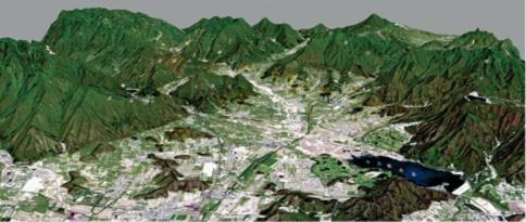
A 3D panoramic image of the Ming Tombs (SPOT-5 image, acquired in May, 2007).

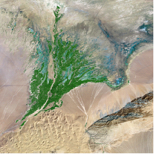
(a) Mss data, image taken in October, 1976. (b) TM data, image taken in 1990.
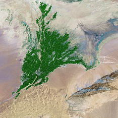
(c) TM data, image taken in July, 2000. (d) TM data, image taken in September, 2007.
Bioenvironmental variation of areas around the Dunhuang Caves during the last 30 years monitored by RS imaging technology.
3.3 Fine mapping of Fo Xiang Ge (Tower of Buddhist Incense)
Sponsored by the Compass Program of the State Administration of Cultural Heritage, the project on “fine mapping of ancient Chinese architecture” is being carried out jointly by HIST and the administration office of the Summer Palace. Researchers will first review the leading technologies and existing research results on the subject, then use 3D laser scanning, close range photogrammetry and 3D reconstruction technology among other techniques to establish a comprehensive and detailed record on the status quo and historical information of important architectures from ancient China, and try to solve some key technical puzzles in the small-scale mapping, data organization and digital expression of complex ancient structure. Fo Xiang Ge (Tower of Buddhist Incense), the highest and largest architecture in the Summer Palace, is a priority of the project.
The octagonal, three-storied, quadruple-eaved Fo Xiang Ge was built on the south side of Wan Shou Shan (Longevity Hill) with a height of 40 meters and a total area of 1,378.31 square meters. Researchers have collected data from 98 positions and stitched their point clouds with accuracy below 5 mm.

Fo Xiang Ge rebuilt by point cloud data obtained from 3D laser scanning.
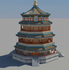
A 3D model of Fo Xiang Ge.
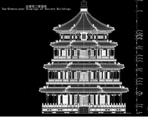
A design drawing of Fo Xiang Ge based on lidar technology.
4. International Training Workshop
Entrusted by the UNESCO Beijing Office, HIST organized the third and fourth East Asian Biosphere Reserve Network (EABRN). The third in the EABRN workshop series, held from March to April 2009, was themed “remote sensing and geographic information systems (GIS) for biosphere reserve management to adapt climate change”. The fourth, themed “application of RS and GIS in biosphere reserve management” , was held in April 2011.
A group photo of the trainees participating in the third East Asian Biosphere Reserve Network (EABRN) workshop.
5. International Cooperation
As an international platform for academic communication, HIST takes the initiative in exchanges and cooper a tion with UNESCO member countries and international organizations, receiving significant attention from leaders of all levels.
During her meeting with UNESCO Director-General I. Bokova, State Councilor LIU Yandong signed a memorandum of understanding on cooperation between China and UNESCO on behalf of the Chinese government and showed her great support for HIST.
Former UNESCO Director-General M. Barbosa, UNESCO Assistant Director-General for Culture F.Bandarin, UNESCO Assistant Director- General for Natural Science G. Kalonji and several other officials visited HIST one after the other. In addition, S&T officer with the UNESCO Beijing Office R. Jayakuma, officials with UNESCO national committee of Korea, UNESCO national committee of Thailand and UNESCO national committee of Japan, and cultural consulate with the German Embassy in Shanghai W. Ecstein also visited HIST respectively.
On the international arena of UNESCO, HIST will further promote its international cooperation, pool strengths in the fields of space technology and World Heritage, add up its capacity in decision-making, public service and technological development and advance the construction and development of this cross-field discipline so as to provide a solid cooperation ground for the Asia-Pacific area and the whole world and contribute to UNESCO and world heritage protection.